Our Work (18)

Residential Development

Written by

MG2A helps residential developers and builders prepare and improve property for the construction of homes.  We help with planning, zoning, subdivision design and approval, and construction of improvements.  We have provided help with substantial residential and mixed use developments in: Bourbonnais, IL Bradley, IL Manteno, IL Manhattan, IL New Lenox, IL Mokena, IL Frankfort, IL…

Contractor Support

Written by

MG2A provides construction phase engineering services for commercial builders and civil site work contractors.  Our recent work includes setting control for GPS operated machinery, setting the location of critical equipment and structural elements, and locating key points during building construction.  MG2A also records as-built conditions for contractors and develops information models for facility owners.  Our…

Site Development Plans

Written by

Our clients buy or own an empty property or a building or facility that they would like to improve or expand.  They deliver important services, manufacture the things we need, or develop and build homes.  MG2A helps our clients plan, design, and get permission to move forward.  If you need a site plan or final…

Streets + Maintenance

Written by

  MG2A has been helping communities and public works departments maintain and improve local roads and streets for over 40 years.  The following graph tells the financial story of street care.  Frequent preventative care costs less than rehabilitation. Our clients have succeeded in effective and sustainable management of their streets by combining proven technology and…

GIS for Private Infrastructure

Written by

Get started using GIS to help you locate, manage, and maintain your “horizontal” infrastructure.   Many facilities owners and managers can implement GIS to access existing site piping, pavement, drainage, and utility data for $5,000 to $10,000.  We can often convert your CAD maps and data to the ESRI ArcGIS Online format at no cost.  Send an email to mg2a@mg2a.com saying you are interested in learning more about GIS and we will send you an email describing our services and the detailed steps, costs, and options available to you. 

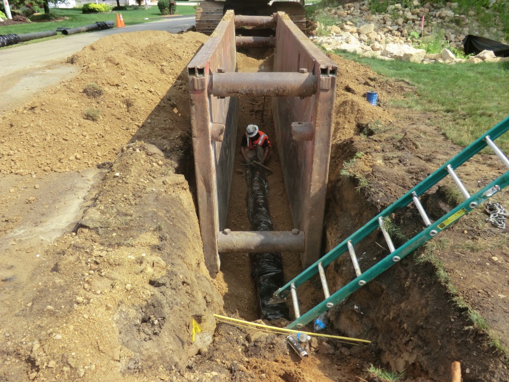
GIS is a particularly effective tool for recording and accessing the location of underground infrastructure.

Our clients are using Geographic Information Systems (GIS) to more effective operate and maintain their site civil infrastructure and manage storm water.  MG2A helps our clients get access to GIS tools, put their information on a map, and develop useful apps to collect, record, access and visualize data. 

The ArcGIS Online Platform
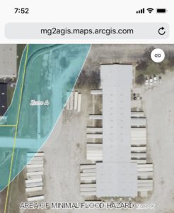
ESRI is a leader in providing GIS platforms and services.  They offer a cloud based GIS platform named “ArcGIS Online” that is a good fit for industrial and commercial facilities and private, local level water, sewer, and other utilities.  ESRI has also developed several models that ease adaptation by private business and provides a constant data format for using existing and developing custom maps and apps .  For example, the “Water Utilities” model provides a platform related to water supply, waste water collection, and storm water management systems.  ArcGIS Online also allows our clients to pull data from county, state, and federal GIS sources and put them in a facility context.  Common data pulled from others include FEMA floodplain, wetland and basic soils data, aerial and satellite images, and local economic zone data and mapping resources.

It costs about $10,000 to get started using ArcGIS with your own organization license .  The ArcGIS Online annual subscription cost is $500 per editor and $100 per user.  Public maps can be published and viewed by anyone at no cost.   You can get started for less than $5,000 by joining MG2A’s organization license.  MG2A is currently building GIS data and capabilities for:

Jennings Realty
Bourbonnais Parkway Business Park

Curwick Development
Cobblestone Residential Facilities

CSL Behring
Infrastructure Location and Information

Godley Public Water District
Water Supply Infrastructure

Martin Industrial Park
Infrastructure Planning and Management

GET THE ACCESS
ATTENTION
AND
SUPPORT YOU NEED

MOVE FORWARD
GET APPROVED
STAY ON PLAN
815-939-4921


GIS for Local Government

Written by

Get started using GIS to streamline your communities administration, public works, building department, and economic development work for $5,000 to $10,000.  We will host your communities ArcGIS Online zoning map at no cost.  Send an email to mg2a@mg2a.com saying you are interested in learning more about GIS and we will send you an email describing…

Land Surveying

Written by

MG2A provides professional land surveying services in Indiana and Illinois.  Our survey crews complete over 400 surveys annually in northeast Illinois and northwest Indianan; including the City of Chicago.  Call 815-939-4921 or order a survey online  if we can help you right now. Our land surveying customers vary from local home owners to national real…

Construction Phase Engineering + Surveying

Written by

MG2A provides construction phase engineering and surveying services for our clients, contractors and builders in Indiana and Illinois.  Our survey crews  work includes setting corners for new homes and commercial buildings, staking the location of caissons and columns, and setting the alignment for utilities and roadways.   Call 815-939-4921 if we can help your team.…